Southern Australia Faces Sudden Temperature Plunge as Warm Streak Ends
After a spell marked by unseasonably high temperatures, much of eastern and southeastern Australia is bracing for a significant atmospheric shift. A powerful cold front is expected to move into the region, signaling an abrupt end to the warm, near-record conditions experienced across several states recently.
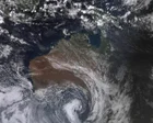
The recent weather pattern was dominated by a high-pressure system that guided warm, northerly winds across the area. This atmospheric setup was responsible for the significant daytime warming, leading to temperatures that were markedly above seasonal norms for early May. However, meteorologists are forecasting a sharp transition, with the arrival of the frontal system bringing not only a notable drop in temperature but also associated inclement weather.
This changing pattern is causing the previously mild conditions to dissipate rapidly. Residents should prepare for a quick return to cooler, more temperate weather, accompanied by potential rainfall and the risk of thunderstorms as the fronts move through.
What This Means for Daily Life
The shift represents a dramatic seasonal swing for the region. Instead of continuing the pleasant warmth, the influx of cooler air suggests a return to more typical late-spring atmospheric behavior. People planning outdoor activities or outdoor work should adjust their expectations for comfort and warmth. The change is expected to be swift, requiring an immediate change in daily preparations and clothing choices.
The incoming weather system is comprehensive, meaning that the cooler air mass will likely accompany precipitation. This contrasts sharply with the dry, stable, and warmer conditions that preceded it. This type of rapid weather change is characteristic of strong frontal passages, impacting everything from local travel to agricultural planning.
Background Context
Weather patterns across southeastern Australia are highly influenced by the positioning and strength of large-scale pressure systems. When a strong, persistent high-pressure zone establishes itself, it can effectively trap and redirect warm maritime air masses inland, resulting in extended periods of elevated warmth, as was observed in the preceding days. The passage of a cold front, conversely, indicates a dramatic collision of differing air masses—warm, moist air meeting cooler, denser air—which is the mechanism that generates the associated weather activity, including potential thunderstorms and significant temperature drops.
Forecasters generally advise monitoring regional updates closely when such rapid transitions are predicted, as the impact of the frontal boundary can be quite immediate and profound across various populated areas.